
Prepare data
Before you start planning and assessing your territory structure, you should prepare your data. Data can be found in companies in a variety of formats. From tables in Excel or Access to systems such as SAP or Microsoft Dynamics. In addition, they are stored in private and shared databases of varying depth, so that it is important to find all the necessary data first.
Often there is a heterogeneous structure with multiple redundantly stored data such as contacts, offers, contracts, product descriptions.
One of the most central questions should always be: Do my data have a spatial reference? The postal code is often used to create this spatial reference. Pharmaceutical districts, administrative levels (e.g. districts, municipalities) or geographic coordinates are other frequently used spatial references.
Data consolidation
A database makes it possible to store and retrieve data efficiently, securely and consistently. In order to ensure a high quality of the data, it should also be sufficiently consolidated.
The aim is to consolidate data:
- Data should be complete and complete.
- Addresses should be cleaned up, i.e. postal corrected and possibly updated. Are there PO box and large recipient postal codes?
- Identify and remove duplicates.
- Visiting addresses should be separated from delivery addresses.
- Data enrichment with external key figures, so that optimisations through additional information are even better tailored to your needs.
Information on the general structure of data in EasyMap can be found in chapter Data Concept.
Geocoding of addresses
Enrichment of address databases by geographic coordinates (longitude and latitude), e.g. with the LT GeoCoder. The addresses are not only geocoded, but also validated and provided with extensive documentation of the quality of the geocoding.
Fields of application:
- precise visualization of locations in maps
- Location and branch network planning
- distance calculation
- Planning of visit tours in the field service
For further information or an online presentation on the LTGeoCoder please visit our website.
Useful data for territory planning
Have you already implemented a sales force structure or assigned your customers to sales representatives? You can use this information to quickly capture your areas in EasyMap.
Define structure
In EasyMap, you must specify the basic building blocks and the levels based on them that make up your territory structure. So before you start working in EasyMap, make sure you understand which is the smallest spatial reference unit you are planning on. These are often postal code areas, pharmaceutical districts, municipalities or geographical coordinates. A sales force structure can consist of one or more levels based on this structure. A structure for a territory structure could look as follows: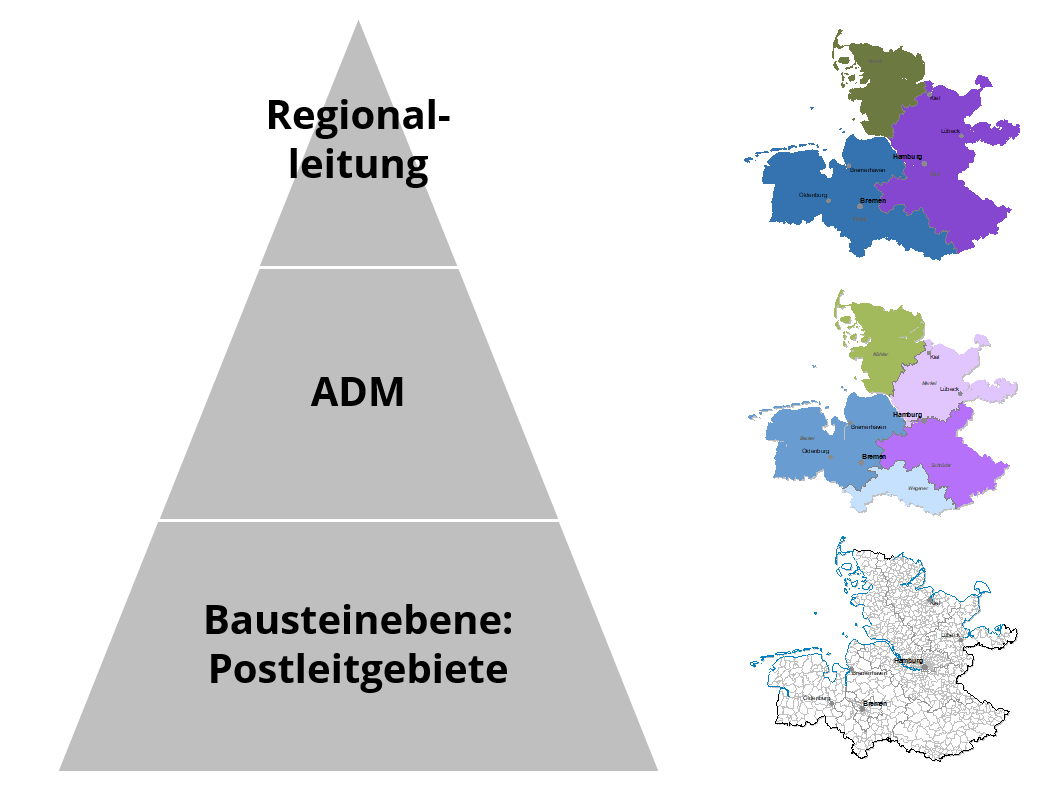
Data for automated area registration in EasyMap
If your sales force structure exists in prepared tabular form, you can automatically display it in EasyMap.
The following examples show which table columns (optional) should exist. The columns relevant for area entry are underlined.
Example 1: Customer list with assignment to field sales representative
| customer number | Company | POSTCODE | ADM number | ADM Name |
|---|---|---|---|---|
| 684651 | Assmann OHG | 53913 | 406 | Schröder |
| 165486 | Shoe store boots | 21149 | 402 | Merkel |
| 987457 | Nursery pear tree | 21717 | 402 | Merkel |
| 953648 | Gritzki Jr. | 54655 | 406 | Schröder |
| 235484 | Sunshine AG | 22089 | 401 | charcoal burner |
| 935748 | Haan Jr. | 01909 | 409 | Becker |
The customer list must contain a spatial reference for each individual customer. In the above example, this applies to the postal code area (PLZ) column. The spatial reference can of course also be via pharmaceutical districts, municipalities, geographical coordinates, etc. In EasyMap, this spatial reference serves as the basic building block on which your territory structure is based.
The assignment of the customer to the respective sales representative is also stored in the table. To do this, you need the name and/or number of the sales representative in each column. If you only have the name of the sales representatives, please make sure that the names are unique. This means that all employees have a different name in the name column.
If your sales force structure is made up of more than one level, for example, another level of regional managers, you can also store this in the customer list with name and/or number:
| customer number | Company | POSTCODE | ADM number | ADM Name | Regional Management Number | Regional Management Name |
|---|---|---|---|---|---|---|
| 684651 | Assmann OHG | 53913 | 406 | Schröder | 3 | west |
| 165486 | Shoe store boots | 21149 | 402 | Merkel | 1 | north |
| 987457 | Nursery pear tree | 21717 | 402 | Merkel | 1 | north |
| 953648 | Gritzki Jr. | 54655 | 406 | Schröder | 3 | west |
| 235484 | Sunshine AG | 22089 | 401 | charcoal burner | 1 | north |
| 935748 | Haan Jr. | 01909 | 409 | Becker | 2 | East |
Alternatively, the assignment of the ADMs to the regional line (and other levels) can also be recorded in a separate table:
| ADM number | ADM Name | Regional Management Number | Regional Management Name |
|---|---|---|---|
| 401 | charcoal burner | 1 | north |
| 402 | steward | 1 | north |
| 405 | shopkeepers | 3 | west |
| 406 | Schröder | 3 | west |
| 409 | Schmitt | 2 | East |
Note: In EasyMap, the name and number of the sales representative/regional manager, etc., are referred to as basic data.
Example 2: Assignment of postal code areas to ADMs
Have you already systematically recorded which postal code areas (pharmaceutical districts, etc.) are assigned to which ADMs? To display this automatically in EasyMap, we recommend a long list that lists each postal code once in a column (or several times if an area is serviced by more than one employee). Such a table shall list for each postal code the corresponding number and/or name of the ADM:
| POSTCODE | ADM number | ADM Name |
|---|---|---|
| 01067 | 409 | Schmitt |
| 01069 | 408 | Schumann |
| ... | ... | ... |
| 21149 | 402 | steward |
| 21717 | 402 | steward |
| ... | ... | ... |
| 53913 | 406 | Schröder |
| 54655 | 405 | shopkeepers |
| ... | ... | ... |
| 99996 | 409 | Schmitt |
| 99998 | 409 | Schmitt |
Superordinate levels can also be entered directly in this table:
| POSTCODE | ADM number | ADM Name | Regional Management Number | Regional Management Name |
|---|---|---|---|---|
| 01067 | 409 | Schmitt | 2 | East |
| 01069 | 408 | Schumann | 2 | East |
| ... | ... | ... | ... | ... |
| 21149 | 402 | steward | 1 | north |
| 21717 | 402 | steward | 1 | north |
| ... | ... | ... | ... | ... |
| 53913 | 406 | Schröder | 3 | west |
| 54655 | 405 | shopkeepers | 3 | west |
| ... | ... | ... | ... | ... |
| 99996 | 409 | Schmitt | 2 | East |
| 99998 | 409 | Schmitt | 2 | East |
Alternatively, the assignment of the ADMs to the regional line (and other levels) can also be recorded in a separate table:
| ADM number | ADM Name | Regional Management Number | Regional Management Name |
|---|---|---|---|
| 401 | charcoal burner | 1 | north |
| 402 | steward | 1 | north |
| 405 | shopkeepers | 3 | west |
| 406 | Schröder | 3 | west |
| 409 | Schmitt | 2 | East |
Example 3: Locations of ADMs
The best way to manage the locations of the ADMs is to use a table containing the postal code or geographical coordinates of the place of residence for each field representative.
The table with geographical coordinates could look like this:
| Location Number | Location Name | degree of longitude | latitude |
|---|---|---|---|
| 401 | charcoal burner | 8,834 | 52,980 |
| 402 | steward | 10,648 | 54,149 |
| 405 | shopkeepers | 7,029 | 51,525 |
| 406 | Schröder | 8,708 | 50,697 |
| 409 | Schmitt | 11,371 | 47,878 |
